
eRaptor 2.0 RTK GPS
The eRaptor 2.0 RTK GPS is a high-precision positioning and mapping solution engineered to support Electrical Leak Detection (ELD) and geomembrane quality assurance applications on exposed geomembranes.
Utilising RTK correction technology, the eRaptor ensures all detected anomalies and surveyed areas are accurately mapped, logged and fully traceable.
Designed for demanding field environments, the eRaptor provides stable signal performance, rapid data capture, and seamless integration with our leak detection systems. The result is highly detailed survey mapping, improved efficiency, and comprehensive as-built documentation for client reporting and compliance purposes.
Whether deployed on large-scale containment facilities or complex installations, the eRaptor RTK GPS system enhances accuracy, productivity, and confidence in every project.
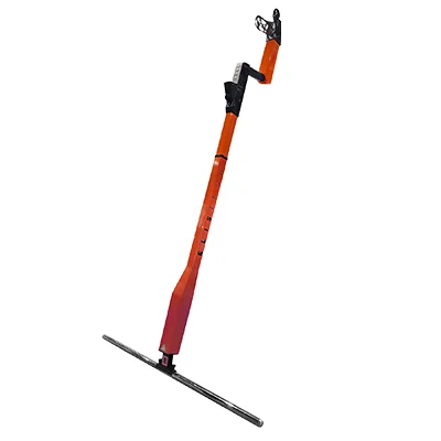
Compact and Lightweight Design
The eRaptor 2.0 is designed with portability in mind. When packed in its robust case, the device measures just 112.7 cm x 40.6 cm x 15.5 cm, and weighs a mere 8.84 kg. The device itself is incredibly lightweight at 3850 grams for the basic model, with the eRaptor+ model including an additional mobile phone, weighing 4150 grams. Unfolded, the device measures 164.0 cm x 10.0 cm x 4.0 cm, ensuring it can be easily transported and quickly deployed.
Extended Battery Life and Quick Charging
With up to 16 hours of operation on a single charge, the eRaptor 2.0 ensures that you can complete extensive surveys without interruption. The built-in lithium-ion battery is rechargeable via USB-C Quick Charge, compatible with 100VAC – 250VAC power sources, offering flexibility and convenience in various settings.
Superior Sensor Technology
Reliable Performance in Tough Conditions
Operating efficiently within a temperature range of 0°C to 50°C, the eRaptor 2.0 is built to withstand challenging environments, ensuring consistent and accurate results every time.
Seamless Connectivity and Data Handling
Utilizing Bluetooth BLE technology, the eRaptor 2.0 allows for data transfer up to 5 meters. With a 4GB data storage capacity and advanced data processing capabilities, users can evaluate and create detailed maps through a mobile app or web portal (exclusive to the eRaptor 2.0+ model).
Intuitive User Interface
Featuring a 0.69-inch full-color display and four physical buttons, the eRaptor 2.0 offers a straightforward and user-friendly interface, enabling operators to control and monitor the device with ease.
Compliance
Complies with ASTM Standards:
D8265-23, D7953-20, D7240-25, D6365-18, D6747-25.
Enhanced Features for Optimal Performance
The eRaptor 2.0 includes a range of advanced features to enhance its usability and efficiency:
- Automatic Shutdown: Conserves battery life when not in use.
- Alarms: Both sound and visual alarms with adjustable settings ensure immediate notification of leaks.
- Historical Data Display: View historical values through detailed graphs.
- Quick Assembly: Assembles in 30 seconds without the need for screws.
- Interchangeable Electrodes: Adaptable to various surfaces.
- High Measurement Speed: Covers up to 10,000 m²/day.
- Adjustable Volume: Control alarm volume to suit your environment.
- Reverse Charging: Use the device to charge other equipment.
- RTK GPS: Provides high-precision location data & GPS coordinate recording
- Ergonomic Handle: Ventilated design for comfortable use.
- Grounding Control: Ensures safe operation with grounding cable attachment.
Highlights
Li-Ion
Rechargable battery up to 12 hours of survey time
For everyone
Two step assamble within 30 seconds
Lightweight
Only 3850g included battery
Fullcolor display
Included visual alarm and more
Shock protection
Multi-stage protection with earthing detection
Self-repair
Order spare part and replace it